<map/>
Example
Note that as an alternative to the example below, the optional lat and long attributes can be used to specify the attributes representing latitude and longitude. Also note that the marker icon function can either return a string that references the image resource in the project source code, or it can return a blob type that can be queried from the database and used as the marker icon as with the dynamic map legend (this is available from version 1.33 of the Helium DevClient).
<map latitudeAttribute="latitude" longituteAttribute="longitude">
    <collectionSource function="getFarmers"/>
    <markerAction label="marker_action.view_farmer_details" action="viewFarmer">
        <binding variable="selectedFarmer"/>
		<visible variable="uSystemConfig">
			<attribute name="showGymMapMarkerActions"/>
		</visible>
    </markerAction>
    <markerTitle value="getMarkerTitle"/>
    <markerIcon value="getMarkerIcon"/>
    <markerDesc value="getMarkerDescription"/>
</map>
unit FarmerMap;

Farmer selectedFarmer;
SystemConfig uSystemConfig;

void init() {
	uSystemConfig = ConfigUtil:getSystemConfig();
}
string getMarkerTitle(Farmer farmer) {
    return String:concat(farmer.firstName, " ", farmer.lastName);
}

string getMarkerDescription(Farmer farmer) {
    return farmer.farmAddress;
}

string getMarkerIcon(Farmer farmer) {
    return "Person";
}

Farmer[] getFarmers() {
    return Farmer:equals(deleted, false);
}

DSL_VIEWS viewFarmer() {
    return DSL_VIEWS.FarmerUserDetails;
}
marker_action.view_farmer_details = View details:
The newline character, \n, can be used to split the text in map marker info windows into more than one line of text.
Icon recommendations
The recommended format for icons is a width of 40 pixels with a height of 30 pixels (or larger but with the same aspect ratio) png images with an alpha channel included.
Map Legend
As of Helium 1.13, a map legend can be specified for the data map widget. Two different aspects of the legend is configurable namely the position of the legend on the map, and the keys represented by the legend. For each legend key, an icon and translated key label has to be specified.
Specifying Map Legend Keys
Each map legend key is individually specified. For each legend key an icon and a label must be specified. The icon is specified by providing the file name, without file extension, of an icon image located in the web-app/images folder. The label for a legend key is specified by providing a lang file key that maps to the translated value for the legend key label. The code example and screenshot that follows demonstrates this:
 <map latitudeAttribute="lat" longituteAttribute="long">
    <collectionSource function="getAllGyms"/>
    <markerAction label="marker_action.flag_for_removal" action="flagForRemoval">
        <binding variable="uGym"/>
    </markerAction>

    <markerTitle value="getMarkerTitle"/>
    <markerIcon value="getMarkerIcon"/>
    <markerDesc value="getMarkerDescription"/>
    <markerAnimation value="getMarkerAnimation"/>

    <legendKey label="legend_key.flagged_for_removal" icon="red_cross"/>
    <legendKey label="legend_key.home_gym" icon="home_gym"/>
    <legendKey label="legend_key.outdoor_gym" icon="outdoor_gym"/>
    <legendKey label="legend_key.commercial_gym" icon="commercial_gym"/>
</map>
legend_key.flagged_for_removal = Flagged for Removal
legend_key.home_gym = Home Gym
legend_key.outdoor_gym = Outdoor Gym
legend_key.commercial_gym = Commercial Gym
Note that the map legend keys also support visibility bindings. This means that a specific map legend key can be hidden programmatically using logic that is defined in a presenter:
.
.
<legendKey label="legend_key.flagged_for_removal" icon="red_cross">
	<visible function="showFlaggedForRemovalLegendKey"/>
</legendKey>
.
.
bool showFlaggedForRemovalLegendKey() {
	.
	.
	.
}
Setting a dynamic list for the Map Legend
Helium allows for the map legend to be built dynamically as of version 1.32, instead of defining several <legendKey> child elements in the .vxml file. A new child element, <legend>, has been introduced to the map widget which holds only a single binding. This binding contains a data source attribute that is either a variable or a function similarly to the <collectionSource>. Importantly this data source must be a collection of object type MezLegendKey which is a new non-persistent Helium built-in object introduced specifically for this use. This is the model for this object:
object MezLegendKey {
    string label;
    blob icon;
}
Both the label and icon attributes are comparable to the elements of the <legendKey> with the same names, where the label attribute contains a string label for the specific legend item and the icon contains a blob which will be used as the icon of the item. This blob icon can be of any image/? MIME type, however, it is advised to keep to Helium conventions and use .jpeg or .png images.
We can then replicate the map and legend above by using the following code:
 <map latitudeAttribute="lat" longituteAttribute="long">
    <collectionSource function="getAllGyms"/>
    <markerAction label="marker_action.flag_for_removal" action="flagForRemoval">
        <binding variable="uGym"/>
    </markerAction>

    <markerTitle value="getMarkerTitle"/>
    <markerIcon value="getMarkerIcon"/>
    <markerDesc value="getMarkerDescription"/>
    <markerAnimation value="getMarkerAnimation"/>

    <legend function="getLegend"/>
</map>
MezLegendKey[] getLegend() {
	MezLegendKey[] result;
	ObjectWithIcon[] iconList = ObjectWithIcon:equals(type, "Gym");
	foreach(ObjectWithIcon obj: iconList){
		MezLegendKey newLegend = MezLegendKey:new();
		newLegend.icon = obj.iconAttribute;
		newLegend.label = obj.labelAttribute;
		result.append(newLegend);
	}
	return result;
}
In this way we collect a list from the database which contains the icons we want to use and build our own legend leveraging any other DSL functionality. If the <legend> data source is empty, no legend will be displayed on the map.
NOTE: You cannot use both the <legendKey> and <legend> child elements at the same time on the same <map> widget.
Specifying the Position for the Map Legend
In addition to specifying individual map legend keys, the relative position of the legend can also be specified using the legendPosition attribute on the map widget as follows:
<map latitudeAttribute="latitude" longituteAttribute="longitude" legendPosition="right-center">
.
.
.
</map>
The possible values for the legend position are the following:
- top-center
- top-left
- top-right
- bottom-center
- bottom-left
- bottom-right
- left-top
- left-center
- left-bottom
- right-top
- right-center
- right-bottom
With the exception of "top-right", none of the above values displaces existing google map controls. A value of "top-right" causes the fullscreen button to be moved downward. Using "right-top", however, will not displace the fullscreen button while still positioning the map legend at the top right of the map.
If no legend position is specified for the map widget, a default value of "right-center" is used.
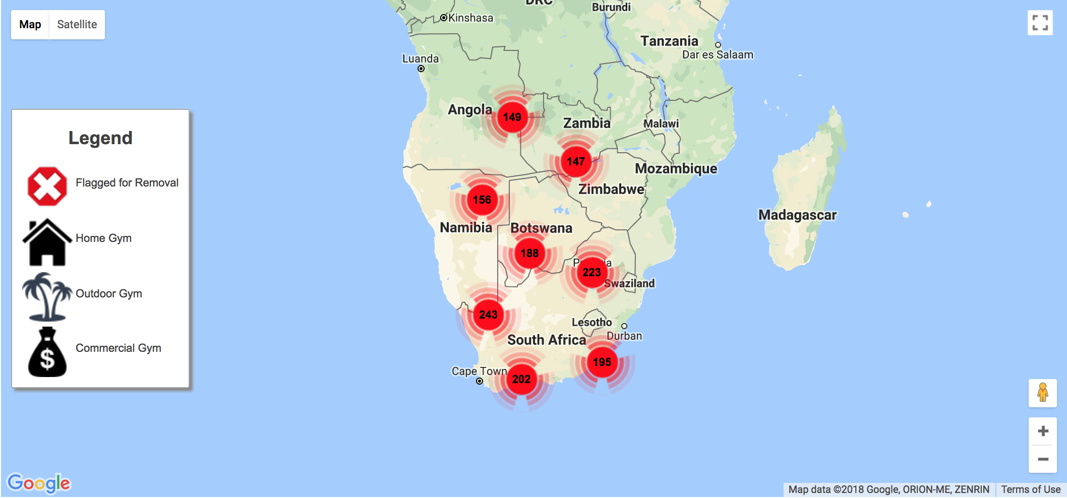
Marker Clustering
As of Helium 1.13, Helium provides marker clustering. Marker clustering groups markers that are close together using a single marker. If the marker is clicked or if the map is zoomed, the cluster icon is replaced by either more clusters representing a reduced number of markers or the actual markers representing the DSL object instance represented in the map collection source. The clustering is done by grouping markers located in fixed grids on the map and is implemented using a default Google Map API clusterer. The cluster icons are also default icons and at this stage and cannot be customised in the Helium DSL.
In order to make use of marker clustering the markerClustering attribute can be used on the data map widget as follows:
<map latitudeAttribute="latitude" longituteAttribute="longitude" markerClustering="enabled">
.
.
.
</map>
Valid values for the marker clustering attribute are "enabled" and "disabled". If marker clustering is not specified, a default value of "disabled" is used.
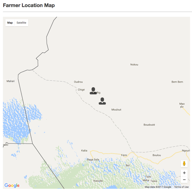
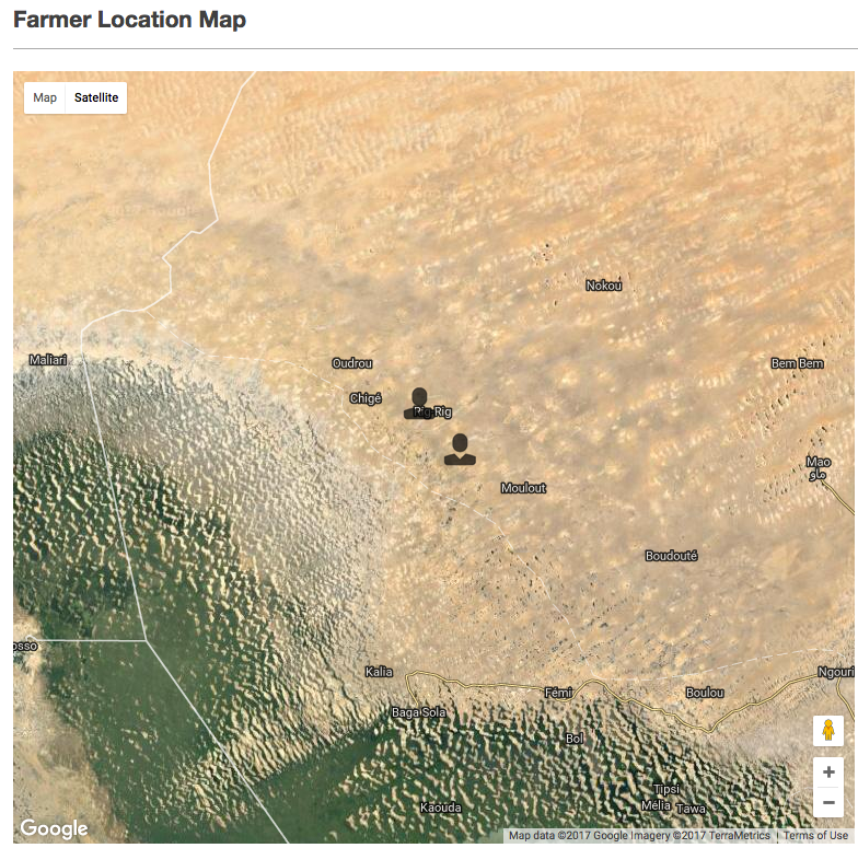
The screenshots below shows how marker clustering is useful when a map is used to present a large number of map markers:
With Marker Clustering Disbled
With Marker Clustering Enabled
Location Actions
In addition to the existing marker actions, the data table widget also provides a secondary type of data action namely location actions.
Whereas marker actions bind to the object instance backing the selected marker, location actions bind to an object instance that is populated by Helium and contains fields relevant to the location from which the location action is triggered. These instances are of the built-in type MezMapLocation.
Location actions can be triggered from any point on a map except from a location that is already occupied by a marker.
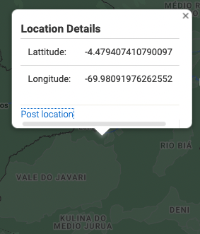
To trigger a location action, users need to right click on the map. They will then be presented with a popup containing a title, the latitude and longitude coordinates of the selected point as wel as a list of the available location actions that can be executed.
The popup title can be specified as a value in the lang file and using the locationActionTitle attribute on the map widget xml. If not specified, the popup title will be blank. The coordinates are populated automatically using the google maps API.
Once an action is selected an instance of MezMapLocation is bound as specified and the specified action is executed.
The example below shows how a location action can be added to a map:
<map locationActionTitle="popup_title.location_action" allowSearch="true" latitudeAttribute="lat" longituteAttribute="long">
    <collectionSource function="AllSelectors:getAllGyms"/>

    <locationAction label="location_action.post_location" action="postLocation">
        <binding variable="location"/>
    </locationAction>
    .
    .
    .
</map>
unit ManageGyms;

MezMapLocation location;
.
.
.
string postLocation() {
    AppLocation loc = AppLocation:new();
    loc.lat = location.latitude;
    loc.lng = location.longitude;
    loc.save();

    return null;
}
popup_title.location_action = Location Details
location_action.post_location = Post location
The screenshot below shows the popup that is rended upon a right click action. From here a location action can be executed: